


One Flow
Live reporting route planner for cyclists: a sustainable solution for an increased sense of safety in urban areas. Community driven infrastructural data generator for cycle paths.
What exactly is One Flow ?
One Flow is a route planner for cyclists: It enables the smooth flow of bicycle traffic between the point of origin and destination. A sustainable solution for an increased sense of safety in urban areas.
What exactly is foodprint ?
One Flow is a route planner for cyclists: It enables the smooth flow of bicycle traffic between the point of origin and destination. A sustainable solution for an increased sense of safety in urban areas.
What exactly One Flow ?
One Flow is a route planner for cyclists: It enables the smooth flow of bicycle traffic between the point of origin and destination. A sustainable solution for an increased sense of safety in urban areas.
What exactly One Flow ?
One Flow is a route planner for cyclists: It enables the smooth flow of bicycle traffic between the point of origin and destination. A sustainable solution for an increased sense of safety in urban areas.
What exactly One Flow ?
One Flow is a route planner for cyclists: It enables the smooth flow of bicycle traffic between the point of origin and destination. A sustainable solution for an increased sense of safety in urban areas.
What is the „Main Goal“ ?
We want to create a system for cyclists that helps the user to find and select suitable and personalized routes that promise a higher sense of safety in urban areas. Live reports help to stay in flow without interrupting the ride.
What is the „Main Goal“ ?
We want to create a system for cyclists that helps the user to find and select suitable and personalized routes that promise a higher sense of safety in urban areas. Live reports help to stay in flow without interrupting the ride.
What is the „Main Goal“ ?
We want to create a system for cyclists that helps the user to find and select suitable and personalized routes that promise a higher sense of safety in urban areas. Live reports help to stay in flow without interrupting the ride.
What is the „Main Goal“ ?
We want to create a system for cyclists that helps the user to find and select suitable and personalized routes that promise a higher sense of safety in urban areas. Live reports help to stay in flow without interrupting the ride.
What is the „Main Goal“ ?
We want to create a system for cyclists that helps the user to find and select suitable and personalized routes that promise a higher sense of safety in urban areas. Live reports help to stay in flow without interrupting the ride.
Design Process
Take a look at the journey we take to create a way to find products that match individual interests and make the ethic choice easier.
Research
Research
Research
Research
Research
Synthese
Synthese
Synthese
Synthese
Synthese
Ideation
Ideation
Ideation
Ideation
Ideation
Concept
Concept
Concept
Concept
Concept
Prototype
Take a look at the solution we create and a way to find products that match individual interests and make the ethic choice easier.
■
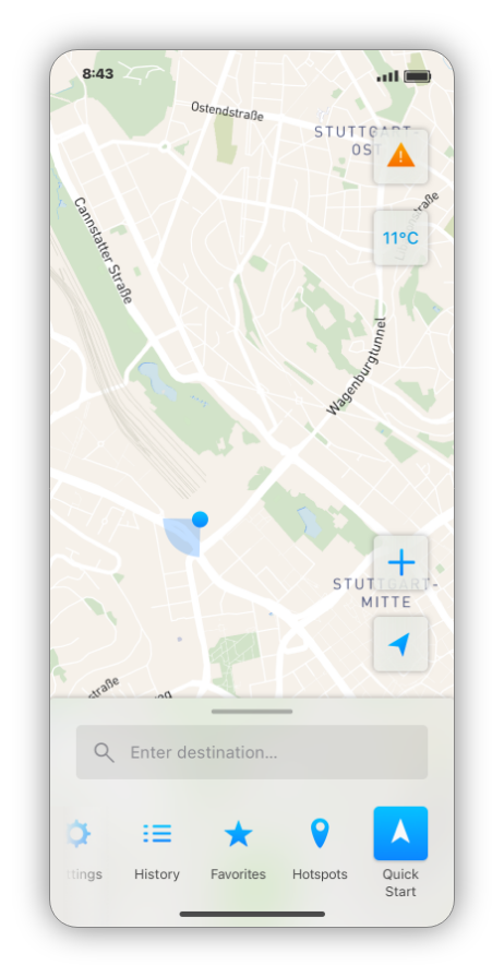
Increasing User Experience:
The Quick Start Button
A quick start function on the right bottom corner is also integrated, which allows to use the app effortless for daily routine routes. This is helpfull for incoming reports and generating data for infastructural tranformations in the future. The button has been visually highlighted to enhance the user experience.
Adobe XD | Sketch | Adobe Illustrator | Mapbox
Increased Sense of Safety in Urban Areas
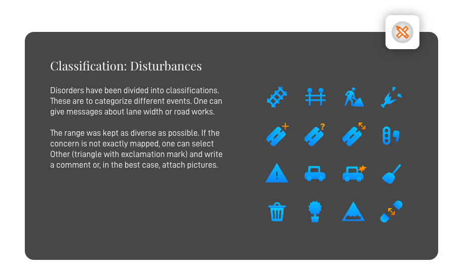
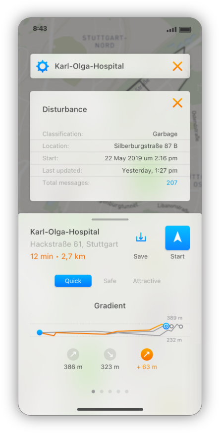
Disturbances on the route, such as potholes or poor condition, are factors that make a pleasant ride difficult and should be eliminated before planning the route. Accompanying green areas additionally increase the quality of the ride, where, on the other hand, heavy traffic and large intersections represent hazardous situations.
Increased Sense of Safety in Urban Areas
Disturbances on the route, such as potholes or poor condition, are factors that make a pleasant ride difficult and should be eliminated before planning the route. Accompanying green areas additionally increase the quality of the ride, where, on the other hand, heavy traffic and large intersections represent hazardous situations.
■
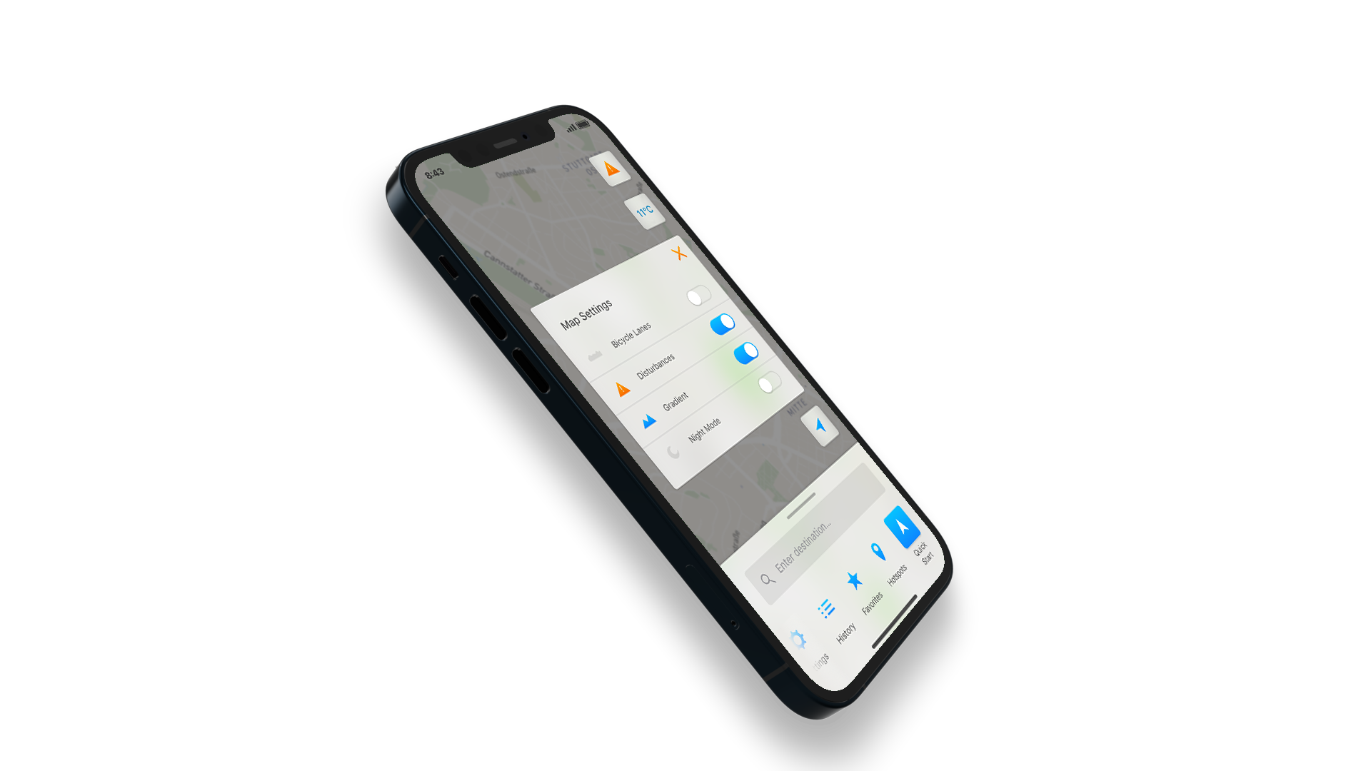
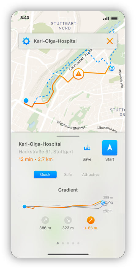
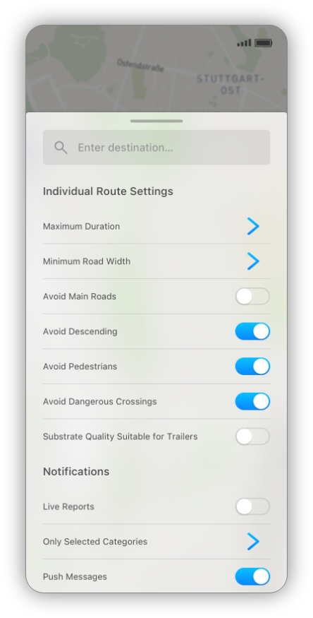
Alternative Routes and Individual Route Prameter
When planning, the user is provided with parameters that allow alternative route properties to be changed, which can create individual routes depending on the concerns. This means, for example, you want to avoid major intersections and look for a safe detour and can select this in the search settings as a filter and get the corresponding route suggested that fits the requirements.
Alternative Routes and Individual Route Pramete
When planning, the user is provided with parameters that allow alternative route properties to be changed, which can create individual routes depending on the concerns. This means, for example, you want to avoid major intersections and look for a safe detour and can select this in the search settings as a filter and get the corresponding route suggested that fits the requirements.
Alternative Routes and Individual Route Prameter
When planning, the user is provided with parameters that allow alternative route properties to be changed, which can create individual routes depending on the concerns. This means, for example, you want to avoid major intersections and look for a safe detour and can select this in the search settings as a filter and get the corresponding route suggested that fits the requirements.
Adobe XD | Sketch | Adobe Illustrator | Mapbox
■
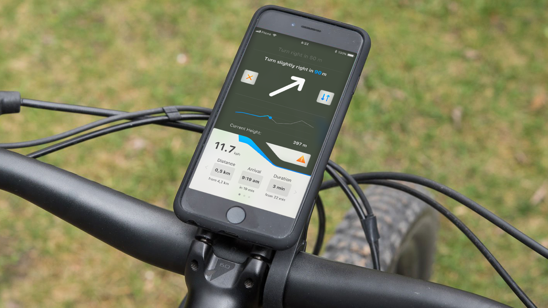
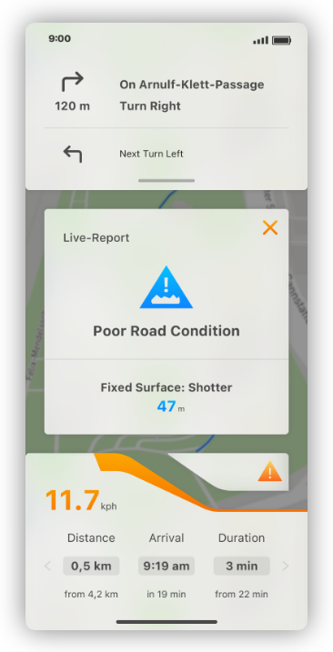
Detailed Informations:
Actuall Conditionings.
With detailed information about the status of the route, journeys can be better anticipated, which significantly increases the feeling of security help prevent danger through trustworthy data.
Detailed Informations:
Actuall Conditionings.
With detailed information about the status of the route, journeys can be better anticipated, which significantly increases the feeling of security help prevent danger through trustworthy data.
Detailed Informations:
Actuall Conditionings
With detailed information about the status of the route, journeys can be better anticipated, which significantly increases the feeling of security help prevent danger through trustworthy data.
Detailed Informations:
Actuall Conditionings
With detailed information about the status of the route, journeys can be better anticipated, which significantly increases the feeling of security help prevent danger through trustworthy data.
Detailed Informations:
Actuall Conditionings
With detailed information about the status of the route, journeys can be better anticipated, which significantly increases the feeling of security help prevent danger through trustworthy data.
Adobe XD | Sketch | Adobe Illustrator | Mapbox
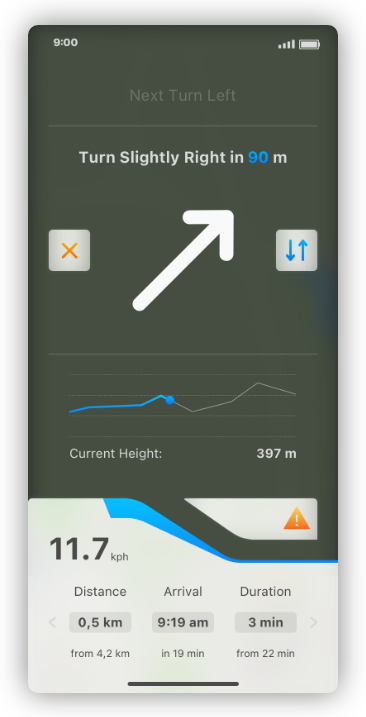
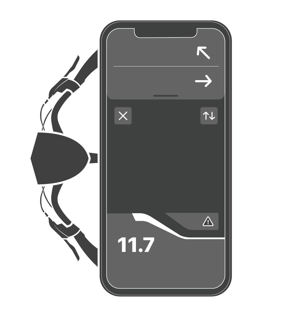
Navigation Function:
Situative Interface Design
The device should not pose any additional danger through distraction, therefore different modes are available. It is possible to switch from the standard view to a reduced view while driving. In this view, information is displayed in a simplified form.
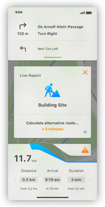
Safety with Live Reports
Messages created and shared by cyclists should serve as real-time incident reports to support the "one flow" effect. This should allow for an automatic bypass of obstacles. The user is spared the need to stop or take a tedious route.
Safety with Life Reports
Messages created and shared by cyclists should serve as real-time incident reports to support the "one flow" effect. This should allow for an automatic bypass of obstacles. The user is spared the need to stop or take a tedious route.
Safety with Life Reports
Messages created and shared by cyclists should serve as real-time incident reports to support the "one flow" effect. This should allow for an automatic bypass of obstacles. The user is spared the need to stop or take a tedious route.
Safety with Life Reports
Messages created and shared by cyclists should serve as real-time incident reports to support the "one flow" effect. This should allow for an automatic bypass of obstacles. The user is spared the need to stop or take a tedious route.
Safety with Life Reports
Messages created and shared by cyclists should serve as real-time incident reports to support the "one flow" effect. This should allow for an automatic bypass of obstacles. The user is spared the need to stop or take a tedious route.
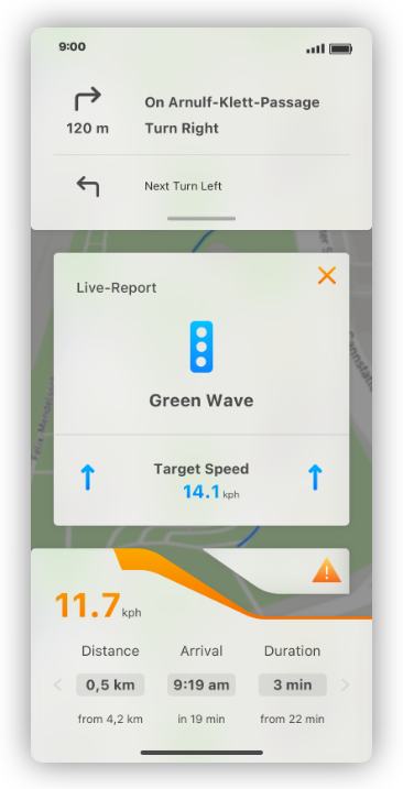
A Journey Without Stops: Green Wave!
During planning, the user is provided with parameters that allow alternative route properties to be set, which allows to create customized routes. For example, one wants to avoid main traffic junctions and is looking for a safe detour. By making settings in advance, customized routes with new requirements can be created.
A Journey Without Stops:
Green Wave!
During planning, the user is provided with parameters that allow alternative route properties to be set, which allows to create customized routes. For example, one wants to avoid main traffic junctions and is looking for a safe detour. By making settings in advance, customized routes with new requirements can be created.
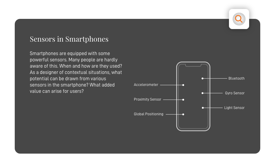
Enhanced Map Information
Sensors provide for the generation of data. The condition and quality of the subsoil is determined by means of gyro-sensoik in the smartphone. These data should provide added value for infrastructural measures, which will serve as a reference for infrastructure measures.
Enhanced Map Info
Sensors provide for the generation of data. The condition and quality of the subsoil is determined by means of gyro-sensoik in the smartphone. These data should provide added value for infrastructural measures, which will serve as a reference for infrastructure measures.
Enhanced Map Info
Sensors provide for the generation of data. The condition and quality of the subsoil is determined by means of gyro-sensoik in the smartphone. These data should provide added value for infrastructural measures, which will serve as a reference for infrastructure measures.
Enhanced Map Info
Sensors provide for the generation of data. The condition and quality of the subsoil is determined by means of gyro-sensoik in the smartphone. These data should provide added value for infrastructural measures, which will serve as a reference for infrastructure measures.
Enhanced Map Info
Sensors provide for the generation of data. The condition and quality of the subsoil is determined by means of gyro-sensoik in the smartphone. These data should provide added value for infrastructural measures, which will serve as a reference for infrastructure measures.
Increasing User Experience:
Community-Driven Map
Data shared by users is put into context, enabling anticipated journeys. In concrete terms, this means that if there are disruptions or other anomalies on the route, these can be recorded with the application and also shared. This is intended to increase the subjective feeling of safety even before the journey.
Increasing User Experience: Community-Driven Map
Data shared by users is put into context, enabling anticipated journeys. In concrete terms, this means that if there are disruptions or other anomalies on the route, these can be recorded with the application and also shared. This is intended to increase the subjective feeling of safety even before the journey.
Decision Making and Think Process
At this point the user can get insights about
information of the chosen product which are
not obviously recognisable. The target here is
to break barriers in the decision making of a
customer. Which provides good products
with a conscoius purchase from the user.
Increasing User Experience: Community-Driven Map
Data shared by users is put into context, enabling anticipated journeys. In concrete terms, this means that if there are disruptions or other anomalies on the route, these can be recorded with the application and also shared. This is intended to increase the subjective feeling of safety even before the journey.
■
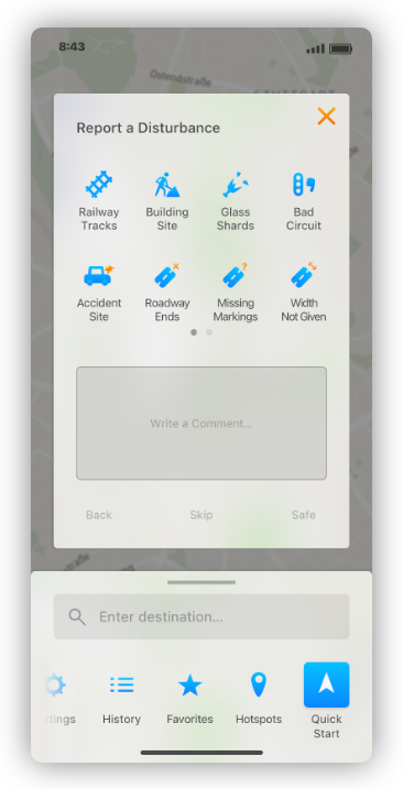
Report and Share Issus
The data shared by users is placed in a context that enables predictive driving. Specifically, this means that if there are disruptions on the route, these can be recorded and also shared with the application. This function is created to increase the subjective sense of safety even before the ride and to enhance the experience for other cyclists as well.
Adobe XD | Sketch | Adobe Illustrator | Mapbox
Project
Bachelor Thesis
7th Semester - Summer 2019
HfG Schwäbisch Gmünd
Project
Bachelor Thesis
7th Semester - Summer 2019
HfG Schwäbisch Gmünd
Project
Bachelor Thesis
7th Semester - Summer 2019
HfG Schwäbisch Gmünd
Project
Bachelor Thesis
7th Semester - Summer 2019
HfG Schwäbisch Gmünd
Project
Bachelor Thesis
7th Semester - Summer 2019
HfG Schwäbisch Gmünd
Technologies
Adobe After Effects
Adobe Illustrator
Adobe Photoshop
Adobe InDesign
Mapbox Studio
Xcode - Swift
Adobe XD
Sketch
Flinto
Technologies
Adobe After Effects
Adobe Illustrator
Adobe Photoshop
Adobe InDesign
Mapbox Studio
Xcode - Swift
Adobe XD
Sketch
Flinto
Technologies
Adobe After Effects
Adobe Illustrator
Adobe Photoshop
Adobe InDesign
Mapbox Studio
Xcode - Swift
Adobe XD
Sketch
Flinto
Technologies
Adobe After Effects
Adobe Illustrator
Adobe Photoshop
Adobe InDesign
Mapbox Studio
Xcode - Swift
Adobe XD
Sketch
Flinto
Technologies
Adobe After Effects
Adobe Illustrator
Adobe Photoshop
Adobe InDesign
Mapbox Studio
Xcode - Swift
Adobe XD
Sketch
Flinto